
Dashain Festival of Nepal: Dates, 15 Days, Traditions and History
The Dashain Festival of Nepal is the country's biggest annual festival for many Nepali families, bringing together religious worship, family…
 Himalayan Gateway Trek - On
 Tenzing-Hillary Airport (also known as Lukla Airport) is one of the world-famous mountain airports. It is situated in the Khumbu region of Nepal, which is a major travel hub for those wishing to travel to Mount Everest and surrounding trekking regions. People look for information on Lukla Airport so they can find out what are the restrictions on the flight, how safe it is, what is the history of the airport, its high altitude, and the short and steep runway.
The mountain environment and its harsh weather conditions have not deterred the airport’s significance for transportation or trekkers and mountaineers, or the local population.
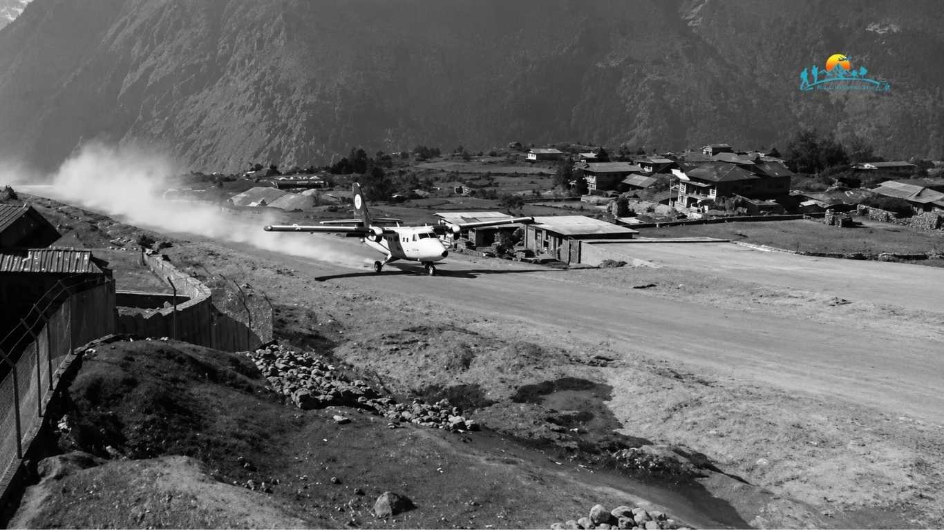
The Everest region was once accessible only by long, challenging treks from lower towns such as Jiri. These journeys could take several days and were physically demanding, limiting tourism and slowing the delivery of essential supplies.
Recognizing the need for a reliable access point, local leaders and mountaineers sought a solution to more efficiently connect the remote Khumbu region to the rest of Nepal.
Sir Edmund Hillary wanted better access to the Everest region for development and emergency services. His efforts led to the construction of Lukla Airport with strong local involvement.
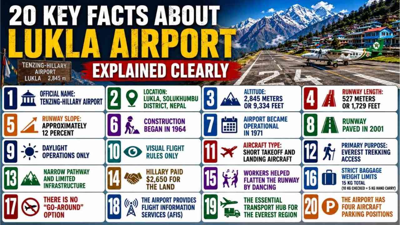
Lukla Airport was renamed Tenzing-Hillary Airport in 2008 to honor Sir Edmund Hillary and Tenzing Norgay Sherpa, who reached the summit of Mount Everest together in 1953.
Lukla Airport is located in the Solukhumbu District of northeastern Nepal. This district lies within the Khumbu region, close to Sagarmatha National Park. The airport’s location in a mountainous valley surrounded by steep terrain directly affects flight operations and approach paths.
This airport is located at an elevation of 2,845 meters above sea level. At this altitude, the air is thinner than at lower elevations. Thin air reduces aircraft engine performance and lift, which means planes need more power and careful handling during takeoff and landing.
The runway at Lukla Airport is only 527 meters long. This is much shorter than runways at standard commercial airports. The limited length leaves no margin for long acceleration or braking, which is why only small aircraft with short takeoff and landing capability can operate here.
The runway has an upward slope of about 12 percent from south to north. This slope helps aircraft slow down during landing and gain lift during takeoff. Without this incline, safe operations on such a short runway would be much more difficult.
Construction of Lukla Airport began in 1964, with local workers helping develop the runway in the mountainous area.
The airport became operational in September 1971, providing a faster way to reach the Khumbu region.
The runway was originally unpaved and was paved with asphalt in 2001, providing a stronger and more reliable surface for aircraft operations.
Flights to and from this airport operate only during daylight hours. The airport does not support night operations because it lacks runway lighting and instrument landing systems. Visual visibility is essential for safe landings.
Lukla Airport operates entirely under Visual Flight Rules (VFR). Pilots must have clear visual contact with the runway and surrounding terrain at all times. There is no radar or instrument landing system available, meaning flights depend heavily on good weather and clear visibility to operate safely.
Only short takeoff and landing aircraft are allowed at Lukla Airport. These aircraft are designed to operate from short runways and perform well at high altitudes. Examples include Twin Otters, Dornier 228, and LET L 410.
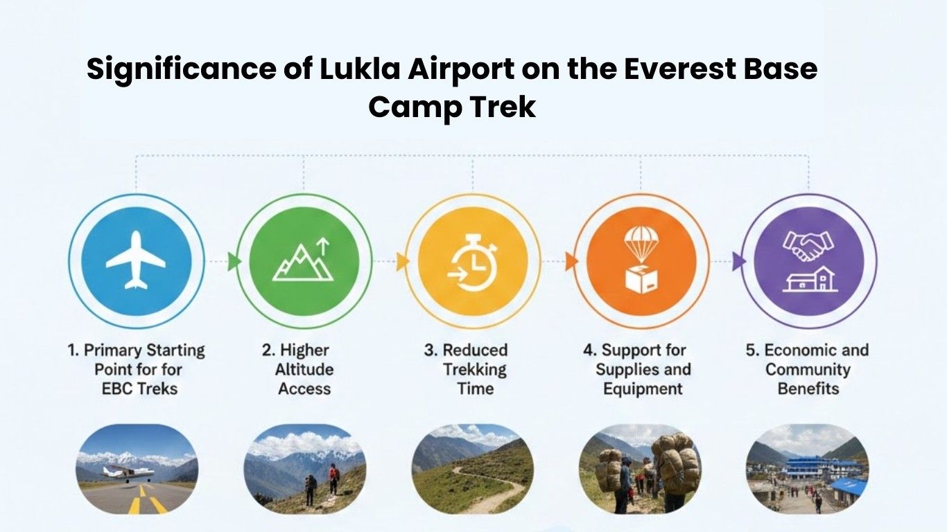
The main purpose of this Airport is to provide access to the Everest region. Most trekkers flying to Everest Base Camp begin their journey here. The airport significantly reduces travel time compared with traditional trekking routes from low-altitude towns.
Steep mountains surround one end of Lukla Airport’s runway, while the other side has a steep drop. This gives pilots very little space to move or change direction. The airport also has a small terminal and limited space for passengers, luggage, and aircraft. Despite these limits, the airport is carefully managed to keep flights as safe as possible.
Sir Edmund Hillary bought the land where Lukla Airport is built, from local Sherpa families, for US$2,650. As a result of the purchase it became possible to open an airfield at the far end of the Khumbu.
During construction of the Lukla airstrip, Sherpa workers reportedly used a traditional foot-stomping dance encouraged with local liquor to help compact the runway soil. Hillary later recounted the unusual episode in his 1998 memoir.
Because the short runway and thin air severely restrict how much weight an aircraft can carry, passengers face strict luggage limits. Trekkers are typically allowed a maximum of 15 kilograms (33 lbs) total—10 kg for checked baggage and 5 kg for a hand-carry bag.
At standard airports, if a pilot approaches at the wrong angle or speed, they can abort the landing, pull up, and circle back to try again a standard maneuver known as a “go-around.” At Lukla, this is physically impossible. Because the short runway is capped at the northern end by a towering mountain wall, once an aircraft commits to the final approach, the pilot has no choice but to land.
Lukla is equipped with an Aerodrome Flight Information Service (AFIS) unit, a service that is used to exchange flight information and alerting to pilots. The AFIS unit does not offer complete air traffic control separation, unlike traditional air traffic control.
Because there are no roads connecting Kathmandu to the upper mountains, Lukla Airport serves as the vital commercial and transport lifeline for the entire Khumbu region. Beyond carrying thousands of trekkers and mountaineers toward Everest Base Camp each year, virtually all heavy cargo, fresh food, medical supplies, and mail flown into the mountains must pass through this single airstrip.
The asphalt apron of the airport is about 65 × 50 m, with a capacity for four aircrafts. The small size of the infrastructure in Lukla and its particular function in the mountains is evident in this small scale of the apron space.
Lukla Airport is located in one of Nepal’s most remote mountain regions. Its position directly affects aircraft operations, which is why the airport is essential for travel to Mount Everest. The surrounding terrain, lack of road access, and high elevation make Lukla the most practical entry point for trekkers and climbers heading into the Khumbu region.
Lukla Airport lies in a narrow mountain valley in the Khumbu region. This region contains some of the world’s highest peaks, including Mount Everest. The terrain limits approach paths and requires precise navigation during flights.
Before Lukla Airport existed, travelers had to trek for several days from road-connected towns like Jiri. Today, flying to Lukla shortens the journey and allows trekkers to begin acclimatization at a higher altitude. This makes Everest treks more accessible while still physically demanding.
Lukla Airport’s location in a narrow Himalayan valley makes air traffic control difficult. Pilots must manage altitude, terrain, and weather carefully. Main challenges include:
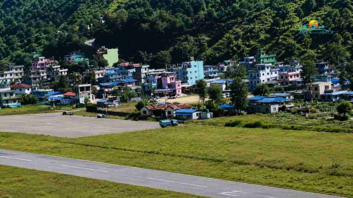
People who plan to fly from Kathmandu to Lukla should be aware that the flight may start from Ramechhap Airport (also called Manthali Airport). Airlines often run flights from Ramechhap to Lukla during peak tour seasons to alleviate congestion at Tribhuvan International Airport.
Ramechhap is a few hours drive from Kathmandu, so it can make a traveller’s itinerary a bit different. Depending on the flight arrangement, trekkers may have to board the flight very early in the morning from Kathmandu or reach Ramechhap the night before.
Due to flight operations variations depending on season and airline schedules, travellers should check with their trekking agency or airline on the airport from which they fly. If the flight departs from Kathmandu or Ramechhap, it will help the travelers to plan their routes, stay and provide enough time for possible delays. The present travel information also shows that the flight from Ramechhap is important during peak periods, for Lukla.
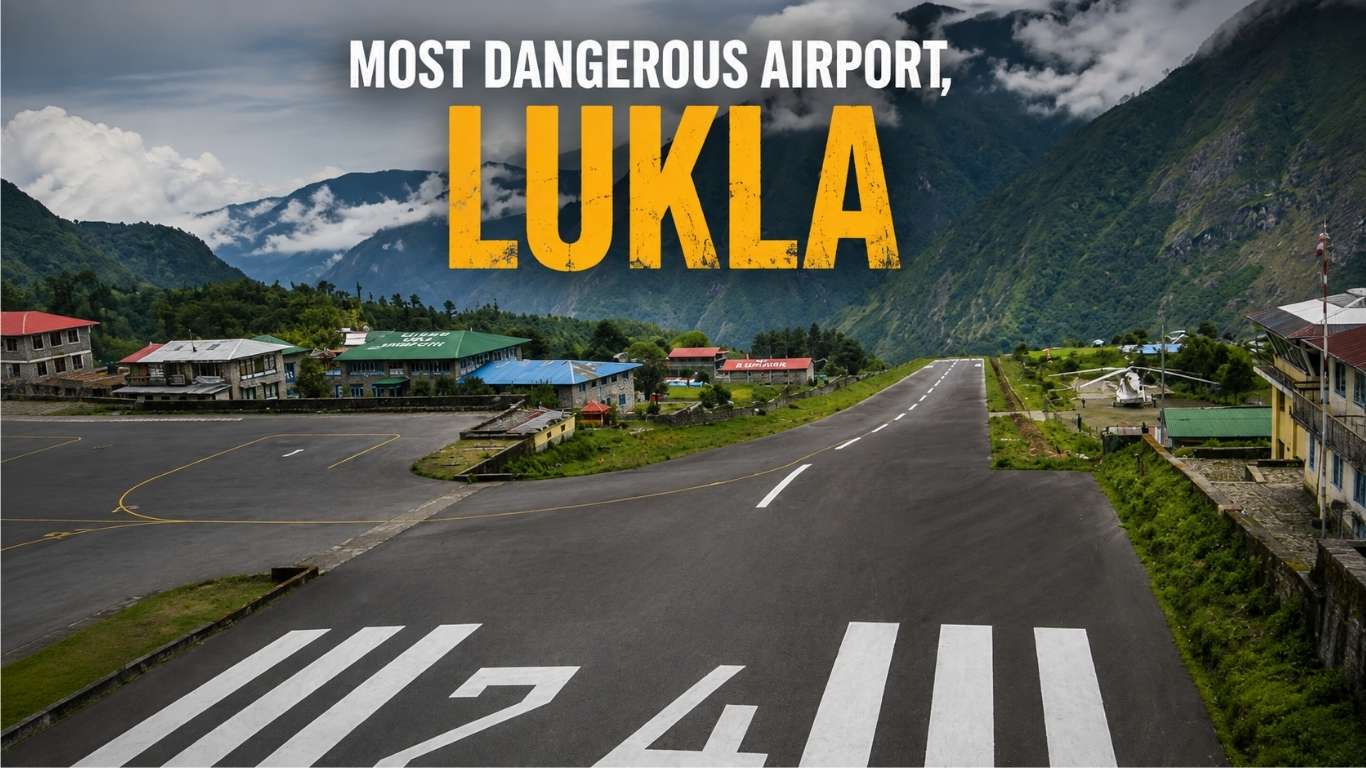
The reason Lukla Airport is a challenge are its short sloped runway, high altitude, surrounding mountains and changes of weather. But its reputation for being dangerous must be taken with a grain of salt.
Yeti Airlines Flight 101, a DHC-6 Twin Otter, crashed upon approach to Lukla on October 8, 2008 in poor visibility. Eighteen of the 19 people on board died.
Since that time, increased pilot requirements, weather rules and mountain flying procedure have been employed to minimise risks. When the weather conditions do not meet the requirements, flights may be delayed or cancelled.
Lukla is more than a dangerous airport for travelers, it is a challenging one. It can be made easier and less stressful if you give the trip a few more days in case of delays, and take the advice of well informed trekking companies.
The flight to Lukla is not a typical domestic flight and requires more experience and skill. High altitude and short runway and surrounding mountains makes accurate flying of particular importance.
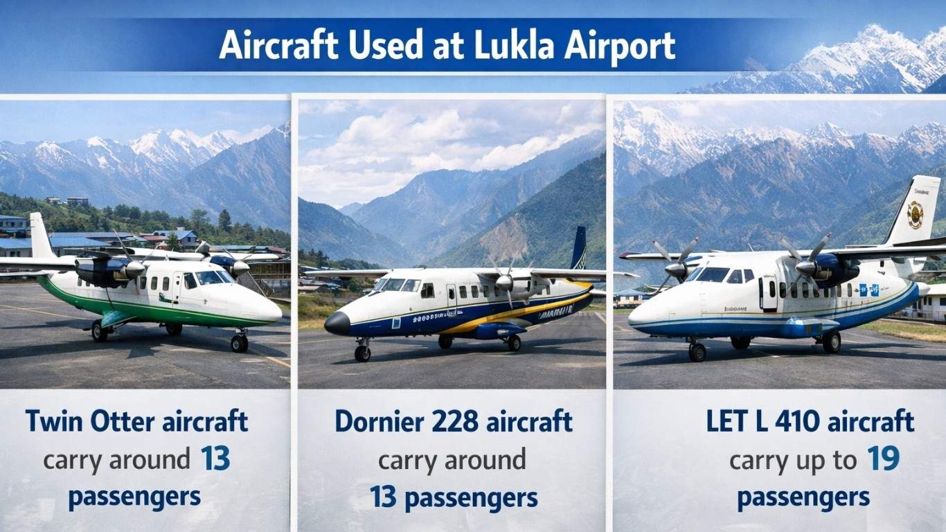
These aircraft are suited to high-altitude and short-runway operations.
Domestic airlines include Tara Air, Summit Air, Nepal Airlines, and Sita Air. These airlines specialize in mountain flying within Nepal.
The airport at Lukla is too small for commercial jets. Large jets require a much longer runway to safely accelerate on takeoff and decelerate on landing, however, and the 527 meter runway is too short.
Lukla is also at an altitude of 2,845m where the air pressure is lower. This decreases the lift on the aircraft and decreases engine performance, making takeoff and landing more challenging. The steep slope of the runway also makes it more suitable for smaller planes that are more likely to fly in to mountain airports than large commercial jets.
High mountains surround the airport and pilots have little room to turn around or try another approach. Due to these conditions, Lukla primarily uses short take-off and landing aircraft (STOL) like the Twin Otter and Dornier 228, which are intended for runways with short length and high altitudes.
In other words, Lukla’s runway is short, its altitude is high, its slope is steep and its surrounding mountains make it not a normal commercial jet.
There is a high degree of flight reliability, but it will vary with the season, weather and time of day at Lukla. It is important to remember that weather conditions in the mountains can turn rapidly, flights can be delayed or canceled if conditions are poor with low visibility or wind.
Clouds can rapidly build up around the Himalayan mountains. Cloud is a hazard in the valley and can descend quickly reducing pilots visibility of the runway and surrounding terrain.
In the narrow mountain valleys, the wind may change direction. Takeoffs and landings may be difficult due to strong crosswinds and/or tailwinds, and flights are only made when the conditions are favourable.
Flights are typically at very early morning, often around 6-7 am when the visibility is typically better and the wind is less. Flights in the afternoon may be less reliable due to higher cloud levels and winds.
| Season | Typical Conditions | Flight Likelihood |
|---|---|---|
| October–November | Clear skies, moderate winds | High |
| March–May | Cool mornings, stable air | High |
| December–February | Cold mornings, intermittent storms | Medium |
| June–September | Cloudy afternoons, heavy rain | Low |
October and November (Autumn) and March and May (Spring) are the best periods of the year to fly to Lukla. Winter can be the ideal time for trekking in the mountains and have fewer people around, but there may be cold weather and some snow on flights. The monsoon season (June – September) tends to be cloudy, rainy, and has more flight cancellations.
Tip: Schedule flights early in the morning and allow extra days for possible delays to ensure smooth travel to Lukla.
Lukla Airport plays a vital role beyond just serving trekkers. It connects remote Himalayan villages to essential services, supports livelihoods, and sustains the local economy year-round. The airport also ensures that supplies and emergency services reach these high-altitude communities efficiently.
Traveling to Lukla Airport requires careful planning due to its high-altitude location, unpredictable weather, and the use of small aircraft. Being prepared can make your journey smoother and more enjoyable, whether it’s managing potential delays, packing efficiently, or choosing the best seat for scenic views.
The establishment of Lukla Airport had a significant impact on tourism in the Everest region. Making travel to the area faster and more affordable led to a notable increase in visitors, especially trekkers heading to Everest Base Camp.
This tourism growth has also positively affected the local economy. Tourism has created employment opportunities for residents and brought in revenue that supports community development projects.
The change can be illustrated with the following figures:
| Year | Number of Trekkers in Sagarmatha National Park |
|---|---|
| 1971 (year Lukla Airport opened) | 40 |
| 1975 | 2,000 |
| 1985 | 10,000 |
| 1995 | 25,000 |
| 2005 | 40,000 |
| 2015 | 50,000 |
| 2021–22 (COVID period) | 26,235 |
Lukla Airport is a carefully managed mountain airstrip that balances access, safety, and geography. Understanding the facts about this Airport helps travelers appreciate why flights operate as they do and why the airport remains essential to the Everest region. Its unique location, short sloped runway, and reliance on skilled pilots make it unlike any other airport in the world. For trekkers and climbers,
Lukla is not just a transit point, it is the beginning of a carefully planned Himalayan adventure.
Lukla Airport, officially Tenzing-Hillary Airport, is located at an altitude of 2,845 meters and has a 527-meter-long runway. It operates only in daylight, serves short-takeoff-and-landing aircraft, and is the main gateway for Everest trekkers.
Lukla is renowned for its daring mountain airstrip, breathtaking Himalayan scenery, and serving as the gateway to Everest Base Camp treks. Its short, steeply sloped runway makes landings and takeoffs both thrilling and challenging, earning it a reputation as one of the most exciting and adventurous airports in the world. The surrounding rugged terrain and unpredictable weather add to the airport’s unique allure, attracting adventurers and aviation enthusiasts alike.
Lukla provides quick access to the Everest region, reducing trekking time from days to hours. It supports tourism, boosts the local economy, and ensures essential supplies and emergency services reach remote villages. The airport also serves as a critical starting point for acclimatization, helping trekkers adjust to high altitudes safely. Additionally, it enables rapid response during mountain rescues, making it vital for climber safety and regional development.
Lukla’s runway measures only 527 meters (1,729 feet), much shorter than standard airport runways. This limited length leaves little room for error during takeoff and landing, requiring precise, swift maneuvers from pilots. The runway also has an upward slope of about 12 percent, which helps slow aircraft on landing but makes takeoffs more challenging. These features make expert piloting crucial to ensure safe operations.
Travelers should anticipate possible delays or cancellations due to the region’s unpredictable weather, particularly outside peak seasons. Early-morning flights are generally safer because visibility is clearer and winds are calmer. It’s recommended to choose airlines with experience operating on the Lukla route for added safety. Some travelers also consider helicopter transfers, which are less weather-sensitive but cost more.