Highest Mountains in the World: Complete Guide to the Top 14 Highest Peaks
Mountains have always inspired people with their size, beauty, and mystery. The highest mountains in the world stand far above…
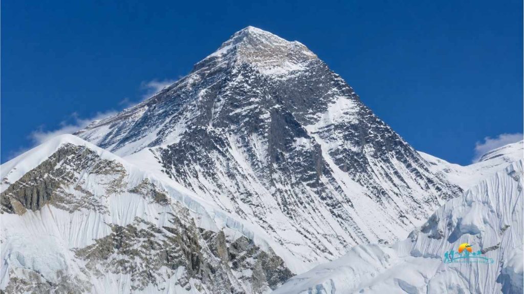
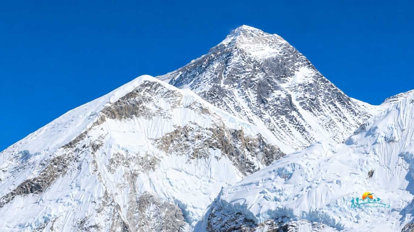
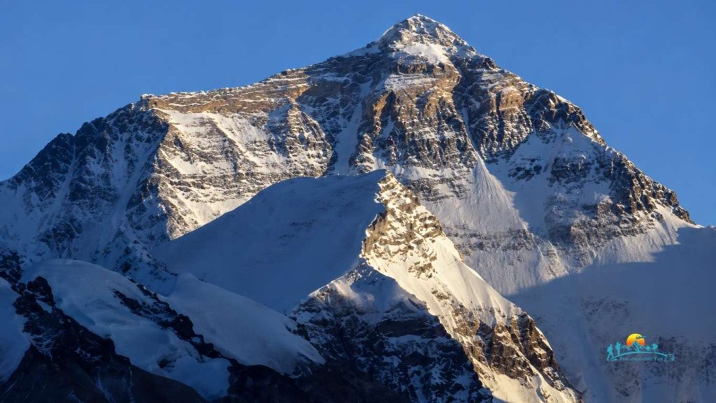
Mount Everest is the highest mountain above sea level and one of the world’s most famous natural landmarks. Standing at 8,848.86 meters (29,031.7 feet), it attracts trekkers, climbers, photographers, and adventure seekers from around the world every year.
Despite its global fame, many people still ask where Mount Everest is located and what makes its location so special. Its position in the Himalayas has shaped the region’s geography, climate, culture, and mountaineering history for centuries.
This guide explains where Mount Everest is located, its exact position on the world map, its height, mountain range, nearby attractions, and other fascinating facts to help you better understand the world’s highest peak.
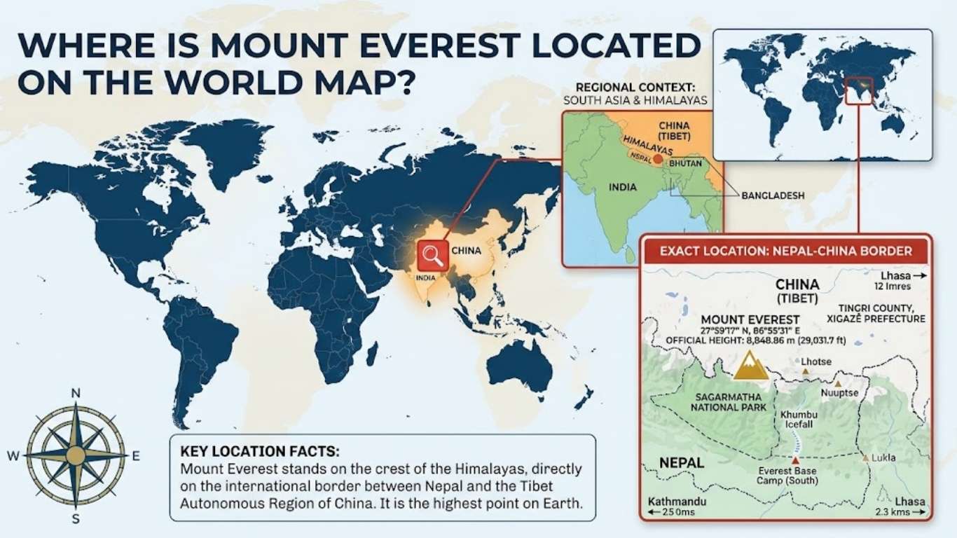
Nepal is in South Asia, close to the border with the Tibet Autonomous Region in China, which is on Mount Everest. On a world map, it is located in the eastern part of the Himalayas, one of the world’s largest mountain ranges.
Its official geographic coordinates are:
The coordinates specify the summit location very precisely and are utilized by climbers, researchers and mapping bodies from all over the world.
There are many web maps that show a map of Everest in Nepal as it is the area where most tourism activities are conducted. This can lead to confusion for travellers. The actual summit is in fact on the international border.
| Geographic Detail | Information |
|---|---|
| Hemisphere | Northern and Eastern |
| Continent | Asia |
| Border | Nepal and China |
| Mountain System | Himalayas |
| Sub Range | Mahalangur Himal |
| Closest Major City | Kathmandu |
| Closest Tibetan City | Lhasa |
If you zoom into satellite maps, you can clearly see the mountain surrounded by several famous Himalayan peaks that together form one of the highest regions on Earth.
The summit of Mount Everest is placed on the international border between Nepal and China, so that is why it is considered to be in both countries. In China it is located in North Face and In Nepal South Face.
This question is confusing because the pictures, documentaries and trekking advertisements will typically highlight Nepal. This means that many people think that Everest is completely located in Nepal. This is not true.
The south side is in the country of Nepal and the north side is in the Tibet Autonomous Region of China. Access, climbing permits, rescue and tourism services are under the control of each country.
| Nepal | China |
|---|---|
| South face of Everest | North face of Everest |
| Sagarmatha National Park | Qomolangma National Nature Preserve |
| Lukla Airport access | Road access from Tibet |
| Popular Everest Base Camp Trek | North Everest Base Camp by vehicle |
| Larger number of climbers | Fewer climbers |
| Sherpa villages | Tibetan settlements |
The Nepal side attracts more visitors because trekkers can experience local culture, mountain villages, monasteries, and famous viewpoints before reaching Everest Base Camp.
The Tibet side offers a quieter experience with easier road access to the North Base Camp but requires additional travel permits.
The Nepal side of Mount Everest is located in the Khumbu region of Solukhumbu District in Koshi Province, eastern Nepal. It is the most popular route to Everest and attracts thousands of trekkers and climbers every year.
Most visitors begin their journey with a flight from Kathmandu to Lukla before trekking through famous Sherpa villages such as Namche Bazaar, Tengboche, Dingboche, Lobuche, and Gorakshep to reach Everest Base Camp.
The mountain also lies within Sagarmatha National Park, a UNESCO World Heritage Site known for its glaciers, alpine landscapes, and unique wildlife.
The region is home to the Sherpa community, whose rich culture and mountaineering experience have made the Nepal side of Mount Everest the preferred choice for most Everest expeditions.
The Nepal side of Mount Everest is located in the Khumbu region of Solukhumbu District in Koshi Province, eastern Nepal. This is the most favored trek towards Everest and draws thousands of trekkers and climbers every season.
Most tourists first fly from Kathmandu to Lukla Airport, and then hike through high Sherpa villages like Namche Bazar, Tengboche, Dingboche, Lobuche and Gorakshep to reach Everest Base Camp.
The mountain is also situated in Sagarmatha National Park, which is a UNESCO World Heritage Site with glaciers, alpine scenery and unique wildlife.
The Sherpa community is native to the area and with their way of life and their experience in climbing, Nepal side of Mount Everest has become the destination of many of the Everest expeditions.
The name Mount Everest was officially given to the mountain in 1865 by the Royal Geographical Society. It got its name from Surveyor General of India Sir George Everest (1830-1843). Sir George Everest was a surveyor, but never climbed the mountain, owing to his work in mapping out the Indian subcontinent.
The mountain has been well known to local people by its name before it was given its English name. In Nepal it is known as Sagarmatha, or “Forehead of the Sky” and in Tibet it is Chomolungma or Qomolangma, “Holy Mother Goddess. The traditional names are still in use and are significant culturally and spiritually of the mountain.
Mount Everest’s exact geographic coordinates help identify its precise location on Earth. These coordinates are used by surveyors, mapmakers, researchers, and mountaineers around the world.
| Location Detail | Information |
|---|---|
| Latitude | 27.9881° N |
| Longitude | 86.9250° E |
| Official Height | 8,848.86 meters (29,031.7 feet) |
| Continent | Asia |
| Border | Nepal and China |
| Mountain Range | Himalayas |
| Sub-range | Mahalangur Himal |
These coordinates place Mount Everest in the eastern Himalayas, close to the border between Nepal and Tibet. Although the mountain is remote, modern satellite technology allows its location to be measured with remarkable accuracy.
The summit is approximately 160 kilometers (99 miles) northeast of Kathmandu in a straight line and about 300 kilometers (186 miles) southwest of Lhasa. Reaching the mountain requires traveling through rugged terrain, which makes the actual journey much longer than the direct distance shown on a map.
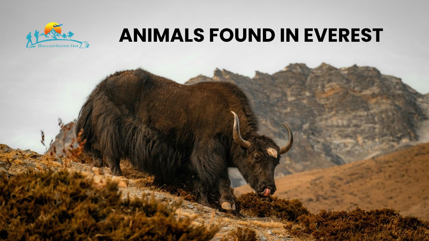
Despite its extreme altitude and cold climate, the Mount Everest region is home to a variety of wildlife that has adapted to survive in harsh mountain conditions. Most animals are found in the forests and alpine meadows of Sagarmatha National Park, while only a few species live at higher elevations.
Some of the most notable animals found in the Everest region include:
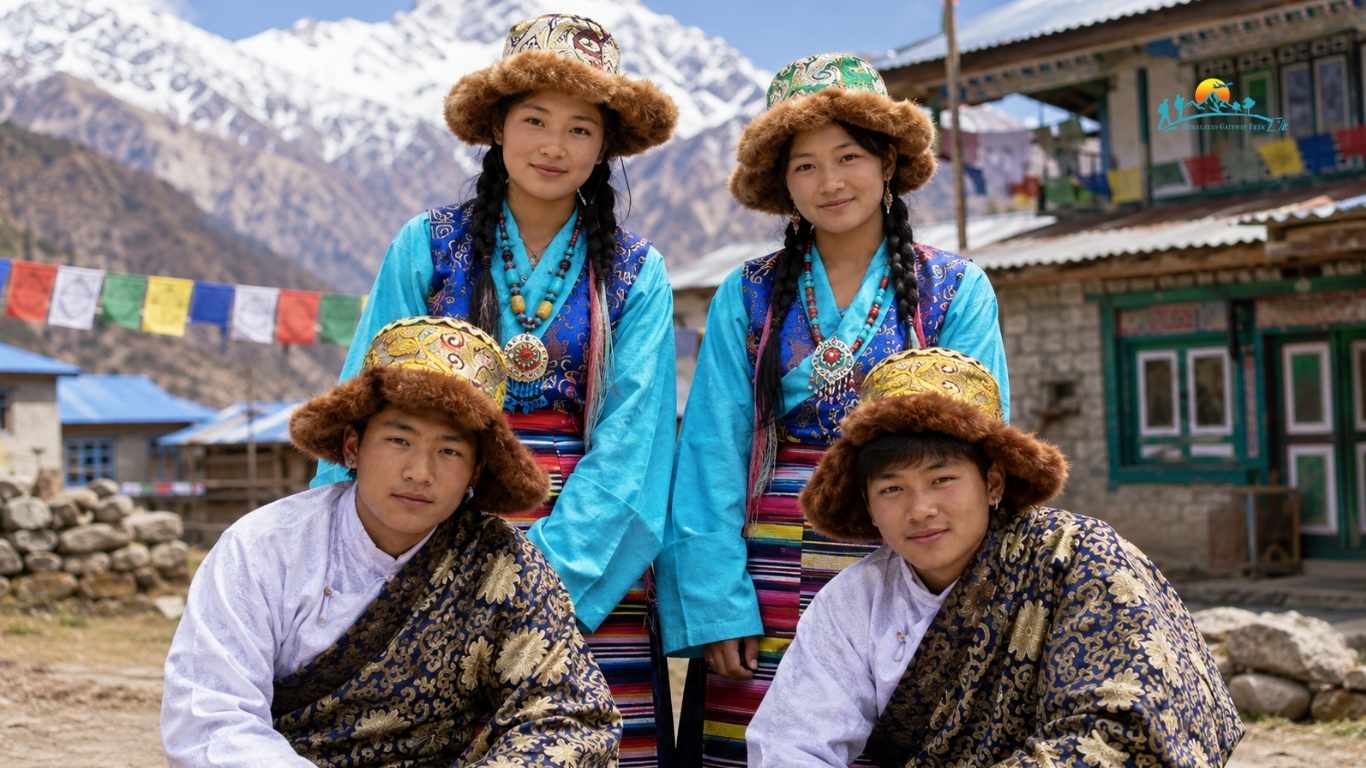
The Sherpa people have been residing in the Himalayas for generations and living in the Everest area. The Sherpa people have a reputation for being able to climb very well and adapt to high altitudes. They work as trekking guides, climbing guides, porters and lodge owners which are important to the tourism industry within the region.
The Sherpa people live in most of the villages in the Everest region, including Namche Bazaar, Khumjung, Tengboche, or Pangboche. The mountains are an integral part of their everyday lives, and trekking through the Khumbu Valley provides an opportunity to taste their hospitality, their traditional stone houses, local food and their centuries-old Buddhist traditions and Buddhist Pilgrims.
Religion plays an important role in the lives of people in the Everest region. Many Sherpa practice Tibetan Buddhism and along the trekking routes, colorful prayer flags, chortens, mani stones and ancient monasteries can be found. The cultural sites are a testament to the community’s reverence for the mountains and their view of the sacredness of Mount Everest, locally known as Sagarmatha and Chomolungma.
In the face of the extreme environment and the high elevation, the Everest region has an extraordinary diversity of plant and animal species. The terrain gradually changes from wooded areas and alpine meadows to rocky areas, glaciers and snow cover as the elevation increases. This rich biodiversity is conserved in the Sagarmatha National Park, a UNESCO World Heritage Site in the Nepal Himalayas, located on the Nepal side of Mt. Everest.
The forest cover in the lower part of the Everest region is rhododendron, pine, fir, juniper and birch. In spring, the mountain trails are alive with colorful rhododendron blooms, making it one of the most beautiful seasons to trek the mountains. Vegetation is sparse at higher elevations and where conditions are suitable alpine shrubs, mosses and hardy grasses grow.
Vegetation is variable in response to altitude and climate. Hardy plants can grow close to the snow line due to low temperatures, windy conditions and a short growing season while dense forests are found at lower elevations. These plants are significant in providing habitat and food for wildlife and help preserve the delicate mountain ecosystem.
There are some rare and well-adapted wildlife species in the Everest region. The visitors may also spot the elusive Himalayan tahr, musk deer, Himalayan serow, red panda, snow leopard and Himalayan black bear.
Birds, like the colourful Himalayan monal, blood pheasant, snow pigeon and yellow-billed chough, are often seen in the skies. These animals have adapted to survive in one of the world’s most challenging mountain environments, making the Everest region an important area for wildlife conservation.
The Himalayas is the highest mountain range in the world and Mount Everest is a part of it. Specifically it is part of the Mahalangur Himal which has some of the tallest peaks in the world.
The region of the Himalayas that is shared by both Nepal and southern Tibet is one of the most dramatic on Earth. There are four mountains above 8000 m in the Mahalangur Himal.
In addition to the height of Mount Everest, it contains the fourth and fifth highest in the world, Lhotse and Makalu, and the sixth highest, Cho Oyu.
The area is also home to other impressive peaks, including Nuptse, Pumori, and Ama Dablam, which are popular among trekkers, photographers, and mountaineers alike.
| Mountain | Height |
|---|---|
| Mount Everest | 8,848.86 m |
| Lhotse | 8,516 m |
| Makalu | 8,485 m |
| Cho Oyu | 8,188 m |
| Nuptse | 7,861 m |
| Pumori | 7,161 m |
Yes, Mount Everest is still growing but very slightly each year. The same tectonic processes responsible for the formation of the Himalayas are still progressively lifting the mountain. Scientists believe that Everest is growing a few millimetres every year but the natural erosion counteracts some of this increase.
The height of the mountain may also be influenced by earthquakes. Highly potent earthquakes can briefly depress or elevate parts of the topography around the area. Due to the changes, they sometimes take new measurements to ensure that the mountain’s official height remains accurate.
Nepal and China jointly announced the present official height of 8848.86 mts (29031.7 ft) in 2020 based on modern satellite technology and ground survey. This revised value has been accepted worldwide and is the most precise measurement to date.
Mount Everest is 8,848.86 meters (29,031.7 feet) above sea level, making it the highest mountain on Earth by elevation. This official height was announced jointly by the governments of Nepal and China after completing a new survey in 2020.
There were various estimates of Everest’s height on maps and guidebooks for many years. In the previous surveys, the values were recorded as 8,848 meters or 8,850 meters, causing confusion among travelers and students. With developments in satellite positioning, GPS technology, and ground surveying, a more accurate measurement of the distance was made possible.
Mount Everest is famous because it is the highest mountain above sea level, for it stands 8,848.86 m (29,031.7 ft) above the Earth’s surface. It is one of the world’s most well-known landmarks due to its unmatched height.
Everest’s climbability and photogenic nature draw visitors from around the world, in addition to its height. It is also significant to the Sherpa community and to Tibetan communities for its cultural and spiritual value. Alongside this, research is conducted on its glaciers, geology and climate to help understand how the Himalayan environment changes.
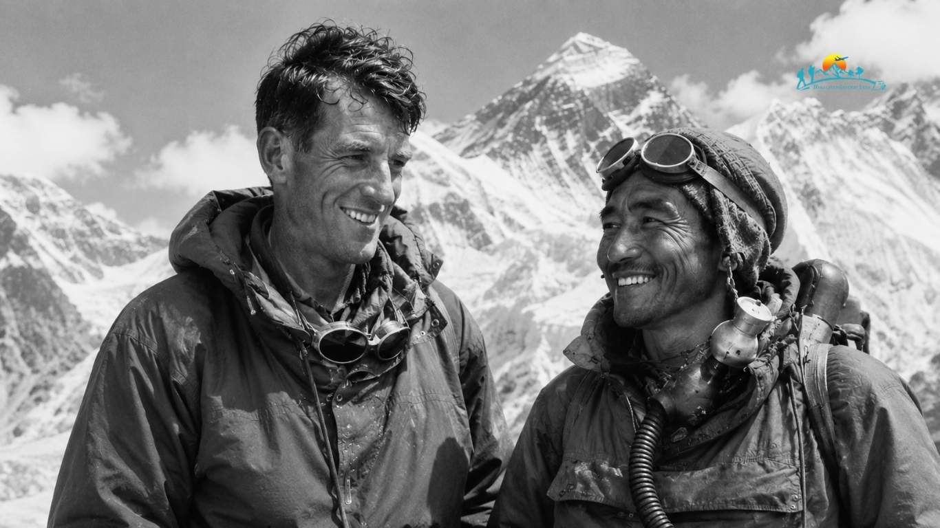
It was on the 29th May 1953 that Sir Edmund Hillary from New Zealand and Tenzing Norgay Sherpa from Nepal successfully climbed up Mount Everest. Their historic feat was the first time a party was able to reach the summit of the world and it’s one of the most important feats in mountaineering history.
British mountaineer Colonel John Hunt led the expedition and it went along the South Col Route from Nepal. After conquering steep ice slopes, freezing temperatures and the “Death Zone” (high altitudes at which the air is so thin that one’s lungs are too weak to support breathing), Hillary and Tenzing climbed to the summit at an altitude of 8,848.86 meters (29,031.7 feet).
Their ascent not only brought to light the success story of Mount Everest but also sparked generations of climbers to try to conquer the summit. The name of Sir Edmund Hillary and Tenzing Norgay is not known just for climbing the world’s highest peak, but also for their enduring legacy in the region of Mount Everest and the Sherpa people.
| Detail | Information |
|---|---|
| First Successful Summit | May 29, 1953 |
| Climbers | Sir Edmund Hillary and Tenzing Norgay Sherpa |
| Expedition Leader | Colonel John Hunt |
| Route Used | South Col Route (Nepal) |
| Summit Height | 8,848.86 m (29,031.7 ft) |
There are two ways to reach Mount Everest, one from Nepal and the other from China, both of which provide different travel experience.
The Nepal route is the most popular route for trekking and climbing in Nepal. The typical route starts in Kathmandu, and then a brief flight to the Lukla Airport (also known as one of the world’s most exciting mountain airports).
After Lukla, walk through the Khumbu region to get to the famous villages of Phakding, Namche Bazaar, Tengboche, Dingboche, Lobuche and Gorakshep and reach Everest Base Camp. The hike typically lasts 12-14 days, providing ample time for acclimatization.
Travelers visiting from China normally begin their journey in Lhasa, the capital of Tibet. From there, they travel by road through the Tibetan Plateau toward North Everest Base Camp.
Unlike the Nepal route, much of the journey can be completed by vehicle, making it possible to reach viewpoints near Everest without a long trek. Visitors must obtain travel permits before entering Tibet, and access is generally arranged through authorized tour operators.
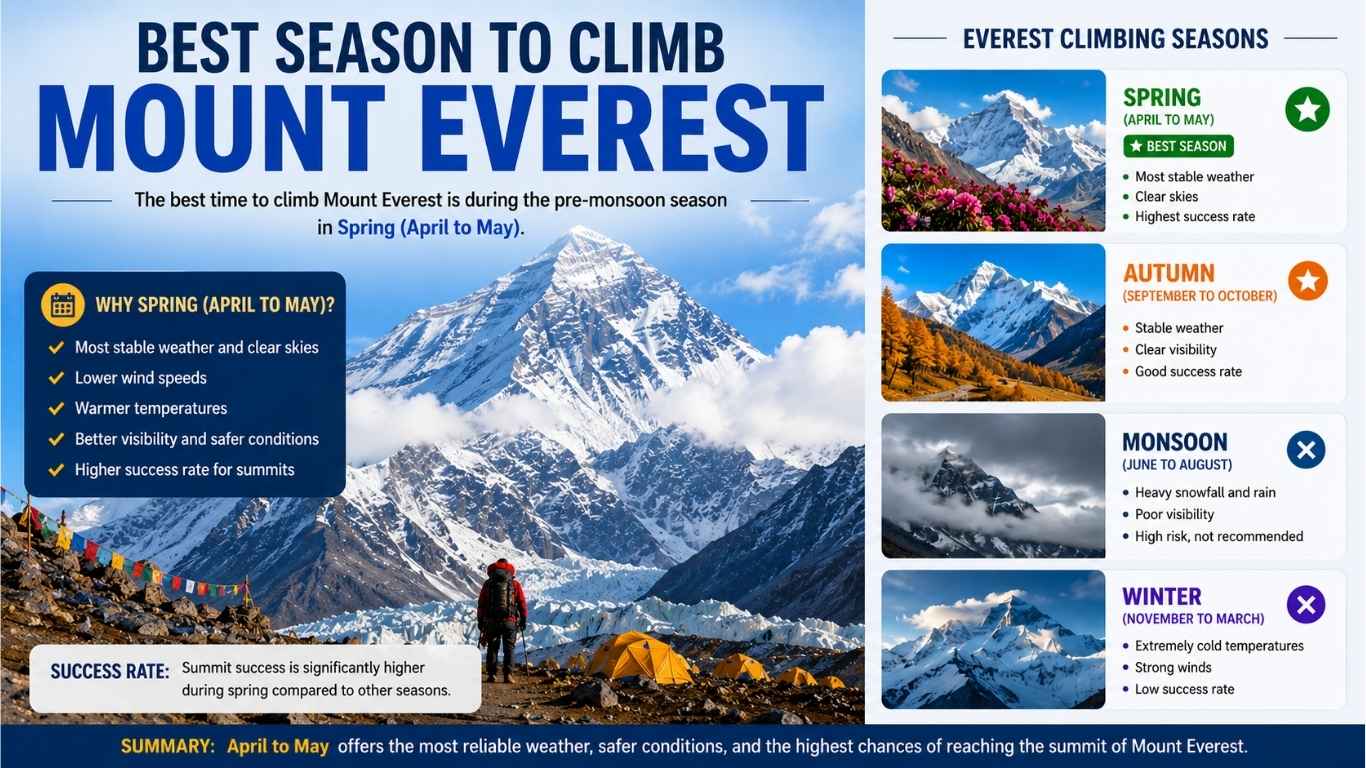
The optimal time for climbing Mount Everest is in the spring (April and May). This is one of the best times of the year to enjoy a nice day, with smoother weather, clearer skies and cooler temperatures. This is why spring is the better time to climb towards Everest, with most climbers on the mountain summit during the month of May.
Spring brings an extended light period and brief spell of relatively calm weather known as the summit window, which is a good time for climbers. Expedition teams spend several weeks at EBC to acclimatise to the high altitude before attempting the summit when the weather is favourable.
Another potential season for climbing is in autumn, starting in late September and continuing through early November. Spring is the busier season, but following the monsoon, the days are typically clear, but colder with stiffer winds and shorter days, so that autumn is less favored. This makes this time of the year less popular for expeditions.
On the other hand, during summer months (June-July-August) there are heavy monsoon rains on the Nepal side, making trekking routes slippery and giving rise to the possibility of avalanches. Climbing is very dangerous in winter (December-February) when the temperatures are very cold, the wind is very strong and the weather is harsh.
| Season | Months | Climbing Conditions |
|---|---|---|
| Spring | April to May | Best weather, stable conditions, highest number of successful summits |
| Summer (Monsoon) | June to August | Heavy rainfall, poor visibility, high avalanche risk |
| Autumn | Late September to Early November | Clear skies but colder temperatures and shorter summit windows |
| Winter | December to February | Extreme cold, strong winds, and very challenging climbing conditions |
This trek to Everest Base Camp is one of the most popular trekking adventures in the world, with stunning views of Mount Everest and other peaks to be seen without climbing to the summit. The route winds through some of the most spectacular landscapes, Buddhist monasteries, suspension bridges and traditional Sherpa villages in the Khumbu region.
Most of the treks start from Kathmandu to Lukla and then proceed for 12-14 days to South Everest Base Camp (5,364 mts/17,598 ft). En route to the tour, the trekkers visit some popular destinations like, Namche Bazaar, Tengboche, Dingboche, Lobuche and Gorakshep.
It is a moderately difficult trek due to the elevation and not the technical climbing. Many people are able to do this unforgettable journey in the Himalayas with a good fitness level and acclimatize themselves successfully with proper preparations.
It is not essential to reach the summit of Mount Everest to have amazing views of the world’s highest peak. There are several viewpoints in the Everest region where trekkers and visitors can enjoy a great view.
Kala Patthar is among the finest viewpoints to Mount Everest. It is about 5,545 meters high and provides a good and unobstructed view of the summit, particularly at sunrise and sunset. Kala Patthar is a popular and popular destination for many trekkers after reaching Everest Base Camp.
Hotel Everest View is situated above Namche Bazaar and is one of the best places to see Mt. Everest. There is a great view of the mountains from the tourist center without the need to climb to the highest places.
Gokyo Ri offers one of the broadest panoramic views of the mountains in the Everest region. On the summit, mountain climbers can view Everest and other Himalayan peaks such as Cho Oyu, Makalu and others. It is surrounded by other turquoise Gokyo Lakes.
Pikey Peak is becoming a popular destination for trail runners seeking more solitude. During clear mornings, the viewpoint provides distant but spectacular views of the mountain, extending across the Himalayas.
For those who seek high-level vistas but don’t want to undertake a strenuous trek, Syangboche near Namche Bazaar is another great viewpoint to visit. This area is easily accessible on foot and offers visitors a stunning view of Everest and other peaks.
Mount Everest’s location makes it one of the most remarkable natural landmarks on Earth. Beyond being the highest mountain, it has several unique geographic and cultural features that set it apart from other peaks.
Over 1000 successful climbs were made in the spring climbing season of 2026, the most in the history of the Mt Everest climbing season. Nepal also issued a record 109 climbing permits indicating the mountain’s popularity among climbers around the world.
Spring climbing permit fee to climb Mount Everest has been hiked by Nepal from $11,000 to $15,000. The new fee is being charged by climbers who are coming up from Nepal to attempt the summit of Everest and forms part of the revised rules governing Everest expeditions.
Nepal has toughened up its rules to ensure safety and to limit the number of people on Mount Everest. The rules are getting tougher with new requirements for stronger climber verification, insurance requirement and plans to require previous climbing experience at high altitudes for Everest expeditions.
Mount Everest is shared by Nepal and the Tibet Autonomous Region of China. It is located in the Mahalangur Himal region of the Himalayas and is officially known as 8848.86 meters (29031.7 feet) tall.
The Nepal side is famous for its Sherpa villages, trekking routes and Sagarmatha National Park, while the Tibet side boasts of the possibility of direct road access and an unrivalled view of the northern face of Everest.
These two regions combine to create one of the most iconic natural monuments in the world – Mount Everest.
Mount Everest is located on the international border between Nepal and the Tibet Autonomous Region of China. It sits within the Mahalangur Himal range of the Himalayas, with its summit forming the actual boundary line.
No, Mount Everest is not located in India. It stands entirely on the international border separating Nepal from Tibet, China. No part of the mountain falls within Indian territorial boundaries.
Commercial planes avoid flying over Mount Everest due to high elevations, severe turbulence, and thin air. In an emergency depressurization, aircraft must quickly descend to 10,000 feet, which is impossible given the towering Himalayan terrain below.
Mount Everest is world-famous as Earth’s highest peak, standing at an iconic 8,848.86 meters. It represents the ultimate symbol of human exploration and extreme endurance, attracting climbers globally to tackle its highly challenging terrain.
Mount Everest is located in Asia on the international border between Nepal and the Tibet Autonomous Region of China. The southern face lies in Nepal’s Solukhumbu District, while northern slopes rise in Tingri County, Tibet.
The exact geographic coordinates of Mount Everest’s summit are approximately 27°59′17″ N latitude and 86°55′31″ E longitude. It sits precisely on the international boundary dividing southwestern China from northeastern Nepal.
According to a joint measurement conducted by Nepal and China, Mount Everest stands at an official height of 8,848.86 meters (29,031.7 feet) above sea level. This figure incorporates its total snow and ice cap depth.
Neither country exclusively owns Mount Everest because it is a shared boundary peak. Following a 1961 boundary agreement, the international border passes directly through the summit, dividing administrative control between Nepal and China.
In Nepal, the mountain is locally called “Sagarmatha,” which means “Forehead of the Sky”. In Tibet, it is known as “Chomolungma,” which translates beautifully to the “Goddess Mother of the World”.
Yes, Mount Everest grows by roughly 4 millimeters annually. This ongoing growth is driven by the slow-motion tectonic collision of the Indian plate continuously pushing upward against the massive Eurasian plate deep underground.
Mount Everest is situated within the Mahalangur Himal, which is a major high-altitude sub-range of the greater Himalayas. This specific sub-range also includes prominent neighboring peaks like Lhotse, Makalu, and Cho Oyu.
In Nepal, the small mountain town of Lukla and the Sherpa hub Namche Bazaar are the nearest populated settlements. In Tibet, Tingri is closest, while Kathmandu and Lhasa serve as major capital gateways.
A standard summit expedition generally requires six to nine weeks from start to finish. Most of this duration is spent setting up camps, resting, and conducting high-altitude rotations to properly acclimatize the human body.